Analysis of Classic Supercell Storm by SVVP Method in Northwest Part of Fujian on 5 March 2010
Oceanography & Fisheries Open Access Journal Juniper Publishers
Abstract
Using the environment physical field, the CINRAD/SA data of Jianyang and the step velocity volume processing method, the hail processes of a classic supercell storm in the northwest part of Fujian Province in China on March 5, 2010, are analyzed. The result shows that the vertical structure of upper dry and lower wet , strong vertical wind shear, positive vorticity in middle-upper levels and mesoscale low pressure in surface provided the suitable dynamic conditions environmental for the classic supercell storm. The appearance of bounded weak echo regions (BWER), lower-level hook echo and three-body scatter spike can be served as hail features of supercell on weather radar echo images. The cyclonic convergence in low levels is important indicator in the initial and developing stages of the hailstorm system.
Keywords: Supercell; SVVP; Horizontal circulation
Introduction
A series of severe convective storms, which caused a large range of hail thunderstorm and strong wind in Nanping and Sanming cities, occurred in the northwest of Fujian Province of China March 5, 2010. Hail with a maximum diameter of 5cm appeared in Shaowu and Mingxi, and a strong wind of 22 m/s appeared in Sanming. These severe convective storms with large impact range and long-life cycle were very rare and had brought huge losses to the local area. Severe convective weather such as hail was highly destructive and high difficulty in weather forecast [1]. The study of Doppler radar two-dimensional wind vector field structure combined with the analysis of radar echoes could guide hail forecast. Hence, conventional observation data and the SVVP (step velocity volume processing) method base on single Doppler radar data were used to analyze these hail processes, in order to improve the early warning of hail.
Analysis of the Weather Situation
At 08:00 on March 5, 2010 (Beijing Time, the same below), there was a Southwest high-altitude jet greater than 32m/s between South Branch trough and subtropical anticyclone of the 500hPa, and Fujian Province was located in forepart of the southwest jet in front of the South Branch trough. There was a mesoscale low pressure caused by the development of ground inverted trough in the north of Fujian Province, the hail area was located in jet region of the 850hPa(≥20m/s). At the same time, the temperature near the surface increased in the past 24 hours. In terms of humidity conditions, Nanping and Sanming cities were in the wet advection zone, which the difference of dew-point temperature was between 1 and 2 ℃ in 850hpa, between 4 and 8℃ in 700hpa, but were in the dry advection zone(> 12 ℃) in 500hPa [2].
Based on the sounding of Shaowu station at 08:00, it can be found that an inversion layer (dry and warm cover) appeared in the lower troposphere (884hpa), which was conducive to the development of deep convection. With the rise of temperature and the approach of the ground cold front in the afternoon, the Convective Available Potential Energy (CAPE) reached 1535J/kg, and the vertical wind shear (39m/s) was obvious [2]. At the same time, the height of 0℃ and -20℃ was 4.0km and 7.1km respectively, which reached the index threshold of hail. The vertical structure of upper dry and lower wet, strong vertical wind shear, positive vorticity in middle-upper levels and mesoscale low pressure in surface provided the better environmental conditions for the supper-cell storm.
Analysis of the Radar Data
Evolution of Radar Echoes
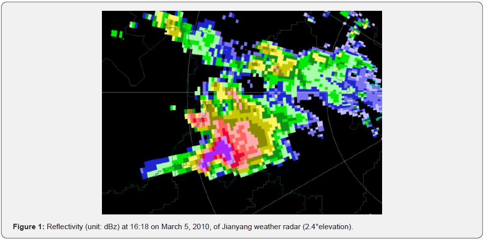
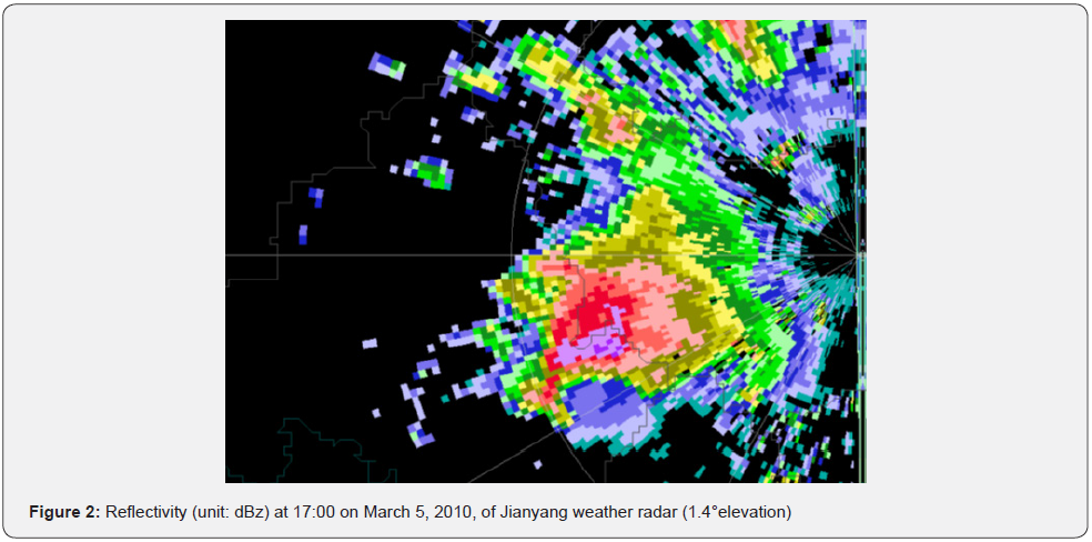
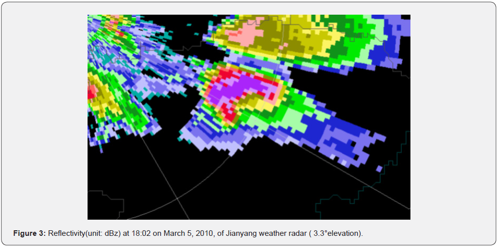
The storm always maintained the relative isolated state and life-history was 4h 52 min, the storm’s average speed was 75 km/h and the storm was a high centroid convective system. During the mature stage (15:57-18:47) the storm maintained the classic supercell characteristics of the moderate intensity or more mesocyclone, the correlative bounded weak echo regions (BWER), lower-level hook echo and three body scatter spike appeared in middle upper levels (Figure 1). Moreover, it came through three times peak development, the mesocyclone of the storm enhanced and stretched to the ground in the peak period. Between 16:52 and 17:17 (Figure 2), the storm appeared the phenomenon of updating lower-level hook echo and disappearing of BWER, these evolving features were in accordance with the model of tornadoarising supercell [3]. Between 17:41 and 18:47 (Figure 3), the storm came up the similar evolving feature but the more typical is the mesocyclone came to occlusion at last, and then the storm formed vortex-echo which lasted half hour. Besides, between 16:03 and 17:17 the gust front echo appeared in the left front of the storm several times rather than right backward, which was favorable for lasting of the storm[3].
Analysis of Horizontal Wind by SVVP
In this paper, an improved VVP (velocity volume processing) method, SVVP (step VVP) method, was used to analyze horizontal circulation and the divergence and vorticity, in the initial and developing stages of the hailstorm system. The SVVP method gets rid of the problem of an ill-conditioned matrix and many kinematic variables can be estimated for mesoscale and smallscale convective systems when smaller analysis volumes are needed. The SVVP method is effective in application and has a much higher accuracy. It has the potential ability to forecast the supercell storm and is beneficial to decrease the loss of hail disaster [4].
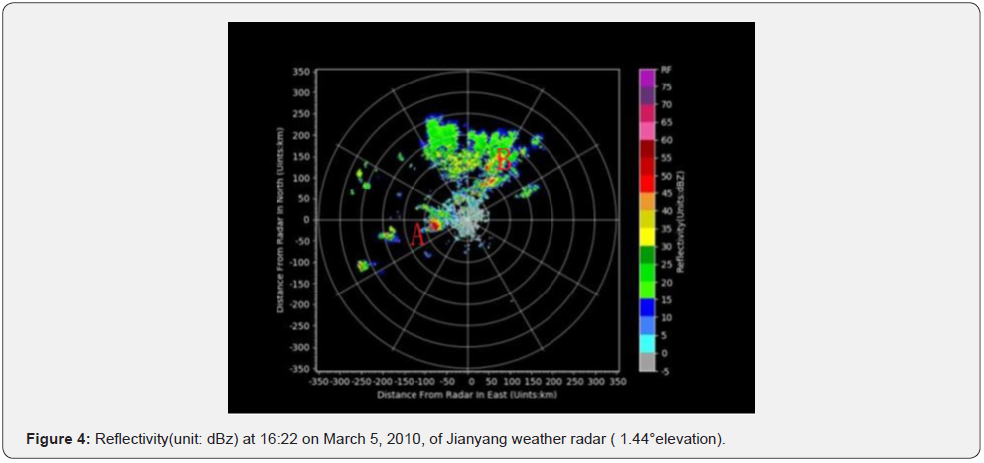
In the afternoon of March 5, 2010, some strong echo of convective weather appeared on the Doppler radar image in the northwestern of Fujian province. It can be seen from Figure 4 that some organized convective cells appear in Nanping and Sanming areas in Northwest Fujian at 16:22. These strong convective cells might develop into super-cell storm with hail and gales and thunder. Figure 4 shows Convective storms can be divided into two parts, one is located in the west of Jianyang radar station (Part A), and the other is in the northeast of Jianyang radar station (Part B). The structure of convective storms A was compact, and the reflectivity was more than 50 dBz with small scale. The structure of convective storms B was loose with multiple echo centers.
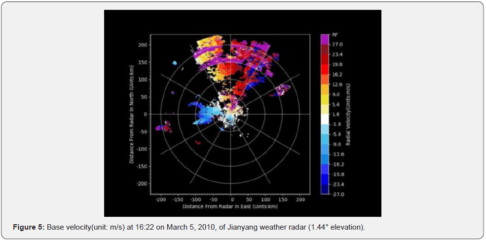
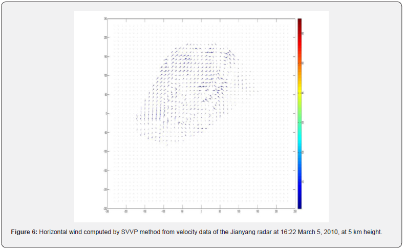
The two-dimensional wind vectors at 5 km above the ground level retrieved by SVVP are illustrated in Figure 6. Southwest winds dominate in the whole wind retrieval area. Southeast airflow enters into the convective storms of part A in the Southeast and turns to become northwest wind cyclonically. West airflow enters into the convective storms of part B in the northwest and turns to become southwest wind anti-cyclonically, while southeast winds enter the south and turn to become southwest winds cyclonically. It can be seen from Figure 5 and Figure 6 the cyclonic circulation existed in lower levels is conducive to the development of convective storms in part A, the shear of horizontal wind promotes the development of convective storms in part B.
Conclusion
We analyzed the hail processes of a classic supercell storm in Fujian Province of China on March 5, 2010. The following conclusions can be drawn:
• The dry and warm lid, strong vertical wind shear, positive vorticity in middle-upper levels and mesoscale low pressure in surface provided the better environmental conditions for the hailstorm.
• The appearance of BWER, lower-level hook echo and three-body scatter spike can be served as hail features of supercell on weather radar echo images.
The cyclonic convergence in low levels is important indicator in the initial and developing stages of the hailstorm system.
To Know More About Oceanography & Fisheries Open Access Journal Please click on:
For more Open Access Journals in Juniper Publishers please click on:
https://juniperpublishers.com/index.php

Comments
Post a Comment