Coastal Vision 2025: A Road Map for Developing Smart Island Ecosystem with Special Reference to Indian Sundarbans- Juniper Publishers
Juniper Publishers- Journal of Oceanography
Indian Sundarbans: A Symbiotic Ecotone of Beauty and Danger
The mangrove dominated deltaic Sundarbans is one of the most attractive and alluring wonderland in the planet Earth, which seems to inspire human being for unique natural creativity. For myriad reasons the Sundarbans has a unique position in the history, geography, literature and socio-cultural aspects of eastern Indian and Bangladesh. Lying at the southern tips of West Bengal where the land meets the sea forming a delta, the Sundarbans is the largest single block of tidal halophytic mangrove forest in the world which is conspicuous for its size and biodiversity. Forming a part of world’s largest fluvio-marine Ganga-Brahmaputra deltaic plain at the confluence of the Bay of Bengal, Sundarbans with its endless diversity of vibrating nature is a suitable habitat of world’s famous luxuriant mangrove forest. Though apparently serene, this is a place where natural beauty and terror coexists. It is awe-inspiring abode of estuarine crocodiles, king cobra and other varieties of serpents and the famous Royal Bengal Tiger which turns the nature’s beauty harsh and vengeful, making the struggle of men for existence in this unique place as an intense task.
Nature has best owed Sundarbans with eternal beauty, but according to climatologists this spectacular deltaic complex is the most vulnerable place for destruction directly caused by climatic changes. As per meteorological records, Sundarbans faces many storms of different intensities during the last couple of centuries, but one of the most destructive one it faced in recent times is Alia, which occurred on 25th May, 2009.
Embankment Damage: A Threat of Concern
The islands of Indian Sundarbans (Some 102 in numbers) are mostly girdled with embankments, which stretch up to a length of about 3500Km. However, because of severe erosion, tidal surges, frequent cyclonic storms and wave action, the stability of the embankment is at stake.
Data collected along and across the rivers of Sundarbans since 1989 reveal four different mechanisms of bank erosion. These are:
i) Erosion due to impact of longitudinal and helicoidal flow in the meandering stream
ii) The thrust of the ebb and flood cycles and fluctuation of the high tidal amplitude
iii) Cohesion of grains attributed by textural parameters e.g. banks composed of sands are eroded more than those of clay or more cohesive material and
iv) Differential subsidence causing piecemeal bank erosion and later modification by waves near the mouth of the rivers.
The cracking of embankments is a threat to island dwellers of Sundarbans as the saline water of the adjacent estuaries gushes through these cracks resulting in the loss of fresh water fisheries, agriculture, properties (e.g., rapid erosion of brick construction etc.).
Recent data show an alarming rate of coastal erosion in Sundarbans as well as the trend of sea level rise in that region. The present sea level rise in Indian Sundarbans is about 3.14mm/yr. Erosion is an active process all along the shorelines of the Sundarbans. The coastal shoreline of the Sundarbans- the buffer zone between the land and sea is unstable as the waves, currents and wind continuously shift the sands [1]. The northeastern, south-eastern and south-western sides of Sagar Island are facing vigorous erosion due to the concerted acts of various natural processes and anthropogenic activities. The erosion rate from 1996 to 1999 was calculated to be 5.47m/years [2].
Is There any Exit Way?
The Techno India University, West Bengal has a team of dedicated Oceanographers who believe that fighting against the natural forces or resisting the natural calamities is not an easy task. It requires stages like forecasting, decision making, post disaster set up development etc. However, combating the threats through adaptation is a more accepted road map, although it is time consuming. Some adaptations to develop smart coastal ecosystem in Sundarbans are highlighted here.
Smart Embankment
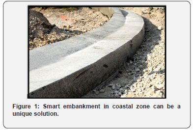
Fly ash is a menace to the environment and causes several adverse impacts on human health and ecosystem. However, this huge by products from the thermal power plant can be used to build embankment in Sundarbans or manufacture bricks, boulders etc. (Figure 1). The embankment may be fitted with wind, saline and current alarms, which should be equipped with sensors to disseminate information if the wind exceeds 50Km/ hr, salinity exceeds 15psu or at a great water velocity.

Smart Construction For Sundarban Islands Dwellers
Building/constructions/houses/farms/sluice gates/ embankments around shrimp farms made from fly ash are more durable, stable and anti-corrosive in nature because fly ash has few unique properties like
i) Minute particles with high density
ii) Reduces the permeability
iii) Extreme strength
iv) Prevents thermal cracking as the concrete mixture generate a very low heat of hydration
v) Resistant to acid an sulphate attacks
vi) Cost effective
Techno India University, West Bengal has already completed a fly ash building at Jharkhali (in the central Indian Sundarbans, where the mean salinity is around 20psu) as a model for such adaptive approach (Figure 2).


Smart Items for Island Dwellers of Indian Sundarbans
Sundarbans has been experiencing more frequent and intense natural disaster since last few decades. This deltaic complex is affected by climate change and more preferably by increasing salinity and extreme weather events like tropical cyclones. The cyclones depression greatly damages properties and push the lives of island dwellers towards danger. Considering this background, some smart items may be incorporated in the daily use items of Sundarban people. These items may be used by the school goers, farmers, fisherman and common people of the islands (Annexure 1). These items can ensure security to Sundarban people during natural hazards like strong winds, wave actions, cyclones, tidal surges and may be considered as important agenda while formulating coastal disaster management policy.
To Know More About Journal of Oceanography Please Click on: https://juniperpublishers.com/ofoaj/index.php
To Know More About Open Access Journals Publishers Please Click on: Juniper Publishers
Comments
Post a Comment