Sea Spaces of Bulgaria
Oceanography & Fisheries Open Access Journal Juniper Publishers
Abstract
Regulating the sea spaces of the UN member states is simultaneously socio-economic, political, international law and scientific and technical issue. Factors for this are the possibilities for exploitation of the seaspaces’resources, the raw materials of the seabed, as well as the protection of the marine environment. The growing shortage of raw materials and resources worldwide is drawing the attention of countries to the seabed, which contains the largest undeveloped resources. Other factors are also important - fishing, aquaculture, maritime transport, tourism, energy sector, underwater cultural heritage, and others. These as paces of Rep. Bulgaria have been regulated since 1987 by the Maritime Areas Act, and since 2000 their legal regime has been regulated by the Maritime Areas, Inland Waterways and Ports Act of the Republic of Bulgaria. It is fully compliant with the norms and principles of the international maritime law, regulated in the UN Convention on the Law of the Sea, which Bulgaria signed on December 10, 1982, and ratified by law on April 24, 1996. In its sea space, Bulgaria exercises sovereignty, sovereign rights, jurisdiction and control in accordance with the norms of international law and the international treaties it has concluded.
Keywords: Inland sea waters; Territorial sea; Adjacent area; Continental shelf; Exclusive economic zone
Introduction
These spaces of the Republic of Bulgaria have five legal categories:
• Inland sea waters;
• Territorial sea;
• Adjacent area;
• Continental shelf;
• Exclusive economic zone (EEZ).
Sea Spaces of Bulgaria
Inland Sea Waters
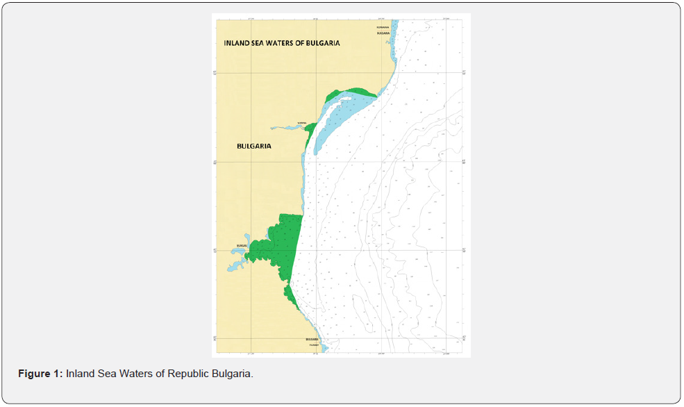
These include the waters between the coastline and the baselines from which the territorial sea is measured. According to the Law on Maritime Areas, Inland Waterways and Ports of the Republic of Bulgaria, these are [1,2] (Figure 1)
i. The waters between the coastline and the straight-line connecting Cape Kaliakra (43°21,6′N; 28°27,9′E) and Cape Tuzla, also called Solnitsa (43°24,0′N; 28°13,2′E). The water area is 50.2 sq. km ddepths reach 15 m and the slopes of the bottom are 0.1% - 0.2%.
ii. The waters between the coastline and the straight-line connecting Cape Tuzla (43°24,0′N; 28°13,2′E) and Cape Ekrene (43°19,7′N; 28°04,1′E). The water area is 34.6 sq. km depths reach 16-17 m, and the slopes of the bottom are 0.1% - 0.2%.
iii. The waters between the coastline and the straight-line connecting Cape St. Constantine (43°13, 7′N; 28°00, 8′E) and Cape Ilandzhik (43°03, 3′N; 27°54, 4′E). The water area is 45.1 sq. km depths reach up to 22 m and bottom slopes range from 0.1% to 0.4%.
iv. The waters between the coastline and the straight-line connecting Cape Emine (42°42,0′N; 27°53,9′E) and Cape Maslen Nos (42°18,4′N; 27°47,6′E) The water area is 782.7 sq. km depths reach 48 - 49 m, and the slopes of the bottom are from 0.1% to 2.6%.
v. The waters between the coastline and the straight-line connecting Cape Maslen Nos (42°18,4′N; 27°47,6′E) and Cape Rohi (42°09,7′N; 27°52,4′E). The water area is 54.4 sq. km depths reach up to 50 m and the slopes of the bottom are from 0.3% to 1.3%.
The total water area of inland sea waters is 967.0 sq. km.
Territorial Sea
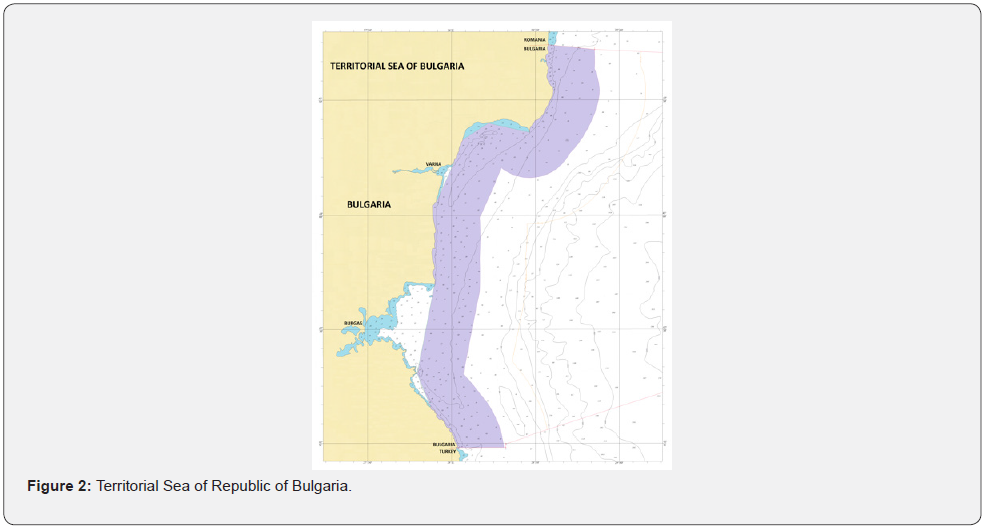
The territorial sea of the Republic of Bulgaria includes the sea strip adjacent to the coast and the inland waters with a width of 12 nautical miles (22 224 m), measured from the baselines. The baselines are the line of the largest ebb from the shore and the straight lines connecting the end points of the inland waters [2,3] (Figure 2). The water area of the territorial sea is an area of 5322.0 sq. km. Depths range from 0 to 86 m and bottom slopes range from 0.2% to 2.0%. The territorial sea of Bulgaria is distinguished from the territorial seas of Turkey and Romania by the sea borders with them. The inland waters and the territorial sea, their bottom and their subsoil are part of the territory of the Republic of Bulgaria, on which it exercises its sovereignty. Their total water area is 6289.0 sq. km. These borders of the territorial sea are a state border of the Republic of Bulgaria. [4,5]
Adjacent Area
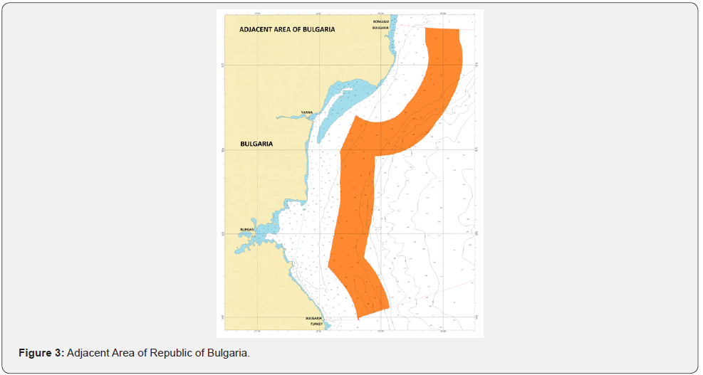
The adjacent area of the Republic of Bulgaria is the sea strip, which borders the territorial sea and extends at a distance of 24 nautical miles (44 448 m) from the baselines from which the width of the territorial sea is measured [2,6] (Figure 3). Bulgaria carries out control to prevent the violation of the customs, financial, border and health requirements of the state in the adjacent zone. The water area of the adjacent area is an area of 5056.0 sq. km. The predominant depths are in the range of 35 to 100 m, but in some sections, they reach 1000 m. The adjacent area includes a large part of the boundary of the continental shelf (continental threshold), which is the depth contour with a depth of 100 m. The adjacent area also includes a small part of the continental slope with depths of 100 to 1000 m. The slopes of the bottom vary from 0.2% in the areas of the shelf to 15% in the sections of the continental slope.
Continental Shelf
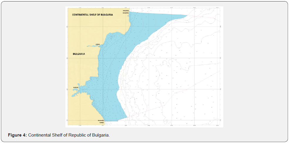
The continental shelf of the Republic of Bulgaria includes the seabed and the subsoil of the underwater region, which are a natural extension of its land territory and extend to the established borders with the continental shelf of the neighboring and opposite countries - Romania, Ukraine, Russia, Georgia, and Turkey. This means concluding bilateral agreements with these countries in accordance with generally accepted principles and norms of the international law. So far, such an agreement exists only with the Republic of Turkey. The most reasonable approach is for the Black Sea states to conduct joint negotiations to clarify the boundaries of the Black Sea shelf [2-4,7] (Figure 4). The outer boundary of the continental shelf can be established on the basis of geological and geomorphologic data. It is outlined by bathymetric profiles, which record the sharp change in the slope of the seabed. From a physical/geographical point of view, the natural boundary of the continental shelf is the continental threshold, after which the continental slope begins, characterized by a sharp increase in depth. For the Bulgarian area of the Black Sea, the continental threshold is the depth contour with a depth of 100 m.
The water area of the Bulgarian continental shelf next to the depth contour with a depth of 100 m has an area of 10 865.6 sq. km. Much of it is in the waters of the territorial sea and the adjacent area. North of Cape Kaliakra, the shelf significantly increases in width, reaching over 75 nautical miles. The slopes of the bottom vary from 0.2% to 2.6%. Bulgaria has sovereign rights to search, explore, develop, use, preserve and manage natural resources on its continental shelf. It has the right to use all energy, mineral and other non-biological resources on the seabed and in its subsoil. Bulgaria has the exclusive right to perform, permit and regulate drilling operations in its continental shelf. The same applies to the construction or use of artificial islands, installations, and structures.
Exclusive Economic Zone
The exclusive economic zone of the Republic of Bulgaria extends beyond the borders of the territorial sea [2]. It may be up to 200 nautical miles from the baselines from which the territorial sea is measured. Its external borders are determined by agreement with neighboring and opposing states in accordance with the international maritime law (Figure 5). The main difficulty in determining (delimiting) the sea spaces of the Black Sea countries stems from its elliptical shape and limited size. For these reasons, no Black Sea country can claim a maximum width of 200 nautical miles in its exclusive economic zone. Bulgaria only has an agreement on the southern border of its maritime areas with the Republic of Turkey.
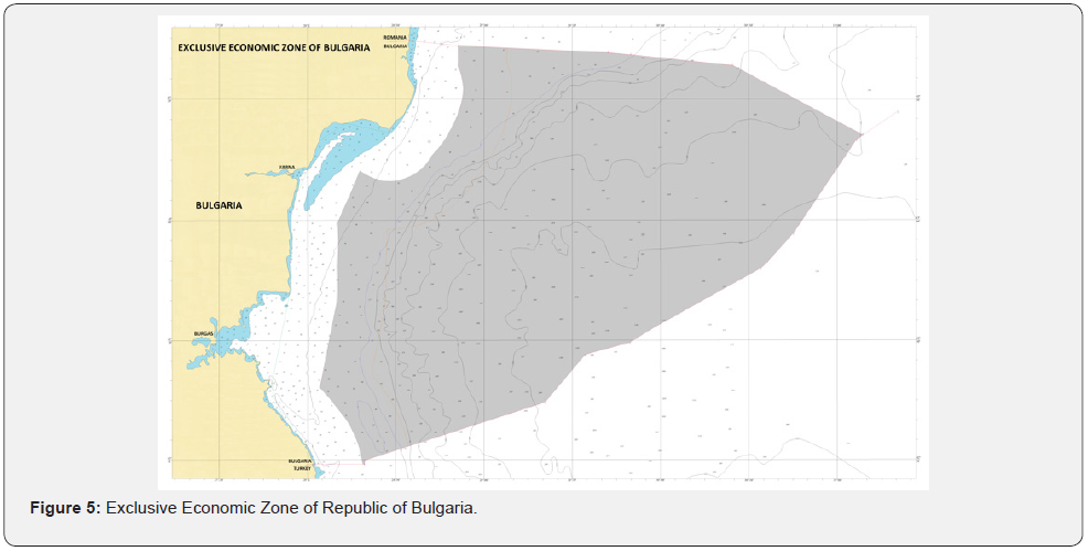
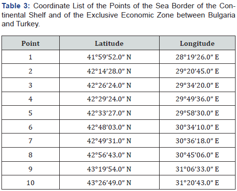
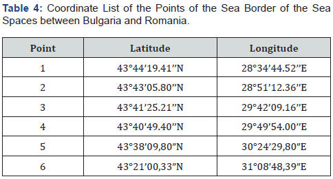
Along the sea borders of Bulgaria with Turkey and Romania, described with the geographical coordinates of the border points in Tables 1, 2, 3 and 4, the water area of the exclusive economic zone of Bulgaria has an area of 28 768.2 sq. km. It includes parts of the continental shelf, the continental slope, and the bottom of the Black Sea. Due to international treaties, Bulgaria has sovereign rights for research, development, use, protection, and management of biological, mineral and energy resources, for research, as well as for the creation and use of artificial islands, installations and facilities and other rights in the EEZ.

Sea Borders of Bulgaria
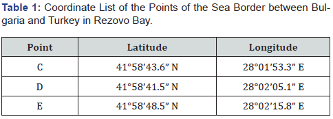
On December 4, 1997, an agreement was drawn up in Sofia between Bulgaria and Turkey for the delimitation of the sea areas between the two countries [3] (Figure 5). It was ratified by a law adopted by the 38th National Assembly on 24.06.1998 and promulgated in SG, no. 68 of 30.07.1999. It defines the end point of the land border between the two countries at the mouth of the Rezovska River. It is parallel to latitude 41°58´59.4’’N. From it begins the sea border dividing the Bay of Rezovo between the two countries with points C, D and E. Point E is at the exit line, closing the internal sea waters of the bay. The geographical coordinates of the points are determined in the coordinate systems of the two countries (Table 1). From point F begins the border of the territorial sea between the two countries. It runs parallel to latitude 41°58’52.8”N through point F and ends at point G. (Table 2) (Figure 5) From point G begins the boundary of the continental shelf and the exclusive economic zone between the two countries, which is defined by 10 points. Their geographical coordinates are defined in the WGS-84 coordinate system. Only the border between 9 and 10 border points, which will be specified after negotiations with Romania and Ukraine is in question (Table 3) (Figure 3) [5,9].
Bulgaria and Romania have been in talks since 1980 to delimit the sea border, but no agreement has yet been reached. Upon joining the European Union, the two countries have committed themselves to defining the boundaries of their sea spaces on the basis of consensus. The territorial sea border with Romania should run parallel to the land border, as has been done with Turkey. The land border with Romania is Cape Sivriburun, which is border point 1 (Figure 5) with geographical coordinates 43°44’19.41’’N; 28°34’44.52’’E. [8,10] The geographic coordinates in the tables 1, 2, 3 and 4 are in WGS 84 coordinate system. At present, the so-called “Working” sea border is established with the sea areas of Romania, which is currently secretly complied with by both countries, which does not cross the border parallel 43°44’19.41’’N (Table 4).
Conclusion
The water area of the sea spaces of Bulgaria, including the internal sea waters, the territorial sea, and the exclusive economic zone, has an area of 35 057.2 sq. km., which is 31.6% of its territory. The easternmost point of our sea spaces is point 6. It lies parallel to Cape Kaliakra and is 117.4 nautical miles from the Bulgarian coast. Due to the limited size and specific shape of the Black Sea, none of the Black Sea states can establish a 200 nautical mile EEZ without harming the interests of other states. Bulgaria has also not exercised its right to enter 200 nautical miles into the sea, but it insists on a fair distribution of the sea areas of the Black Sea states. The most reasonable approach is for coastal states to conduct joint negotiations on the delimitation of their maritime areas in the Black Sea. It would be reasonable for a part of the continental shelf of the Black Sea to be declared a common property of the Black Sea states, which does not contradict the Convention on the Law of the Sea.
To Know More About Oceanography & Fisheries Open Access Journal Please click on:
For more Open Access Journals in Juniper Publishers please click on:

Comments
Post a Comment