The Highest Seawater Level Along the Upper Gulf of Thailand in 100 Years- Juniper Publishers
Juniper Publishers- Journal of Oceanography
Abstract
Information on seawater level in extreme cases is crucial for coastal engineering and management. This research predicts the 100- year seawater level along the upper Gulf of Thailand. Long-term tidal records were gathered from the Marine Department at 3 stations, being Bang Pakong tidal station in Samutprakan province, Ta Chen tidal station in Samutsakhon province, and Mae Klong tidal station in Samutsongkhram province. The records covered more than 35 years. The annual highest high seawater levels were identified for each station. The Extreme value analysis from ordered data was utilized. All tidal stations along the upper Gulf of Thailand indicated an increasing trend of the seawater level. The highest seawater level in 100 years at Bang Pakong, Ta Chen, and Mae Klong tidal stations were expected to be +2.14m MSL, +2.42m MSL, and +2.30m MSL respectively. Applications of the results can be used for designs of coastal structure or implementation of coastal management schemes.
Keywords: Sea level; Coastal engineering and management; Upper Gulf of Thailand; Coastal erosion and inundation
Introduction
The coastal area is susceptible to natural hazards such as coastal erosion and inundation [1-5]. The upper gulf of Thailand has experienced severe coastal erosion originated from both natural causes and human activities [6]. The erosion created by seasonal big waves attacking the shoreline is accelerated by ponds and mangrove destruction. However, developments along the upper gulf of Thailand continue to grow. Many coastal and marine infrastructures have been constructed in Chachoengsao province, Samutprakan province, Bangkok metropolitan, Samutsakhon province, and Samutsongkhram province (Figure 1). These urban expansions need proper planning and protection from natural hazards.

Seawater level is one of the most important parameters that coastal engineers and managers concern as it is directly related to severity of waves attacking the coastline as well as coastal flooding. Misestimating the seawater level during an extreme incident can lead to unacceptable outcomes. From a coastal engineering aspect, the wave height attacking the coastline is the utmost important design parameter. A basic coastal engineering rule of thumb suggests that the breaking wave height is 0.78 times the water depth. If the actual water level is 0.5m higher than the estimation, the wave height will be 0.39m bigger, resulting in a possible failure of coastal protection structures. In a case of revetment design, the rock should be 260kg to withstand a 1-meter wave height but the weight should increase Table 1: Tidal stations along the upper Gulf of Thailand in this study.to 710kg to resist a wave height of 1.39 meters. If a pier is to be built, the elevation of the deck must be above the design water level. Incorrect water level estimation can result in the deck being under water during a storm [7]. From a coastal manager's aspect, water level prediction is a necessary factor in various managerial actions such as the setback line and coastal land use zoning [8]. The residential area should be located outside the risk-prone zone to avoid inundation. Tourism activities should be warned about the dangerous zone where the seawater level may rise and pose a threat to life. Therefore, predictions of the seawater level along the upper Gulf of Thailand during extreme cases are the focus of this research. The results can be useful for academia and coastal practitioners.

Materials and Methods
Long-term tidal records were gathered from the Marine Department at 3 stations along the upper Gulf of Thailand (Table 1). The tidal statistics covered 38 years. A parameter used in this study was the highest high water (HHW), which is the highest seawater level occurring in each calendar year. The time series of HHW of each station was plotted, indicating a trend of seawater level rise/fall. After the time-series of the annual highest seawater level was acquired, the Extreme value analysis from ordered data was utilized [8]. Firstly, individual data was ranked in a deceasing order. Since only extreme values of the seawater level and their ranking were known, the ranking was converted into a plotting position, representing probability of exceedence(Q) (Eq. 1).

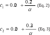
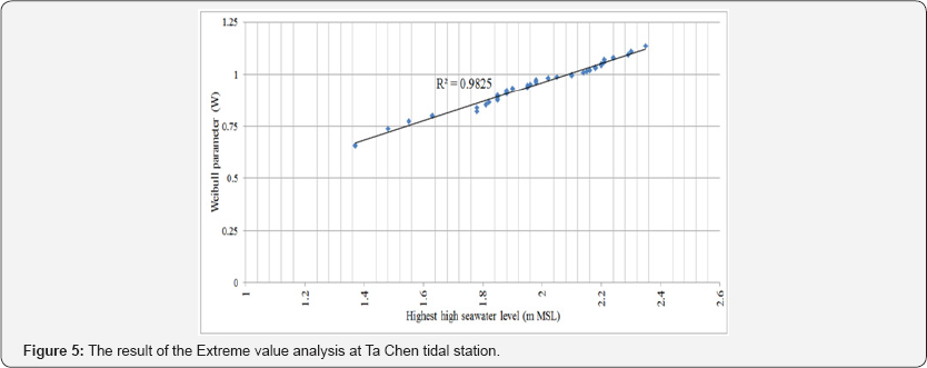
where i is the ranking of the data point, N is the total number of points, and cl and c2 are the constants for unbiased plotting position (Eq. 2 and Eq. 3). In this study, the Weibull distribution was used because it has a flexibility to adjust the curvature of the Weibull graph. Trials of the values were undertaken to achieve the Weibull graph with the highest R2 value.
Results
Three tidal stations along the upper Gulf of Thailand were analyzed to acquire a 100-year seawater level. The plotting results indicated a trend of seawater level rise which is in agreement with many authors [9,10]. The 100-year seawater level can be indispensable information for coastal practitioners.
Samutprakan province (bang pakong tidal station)
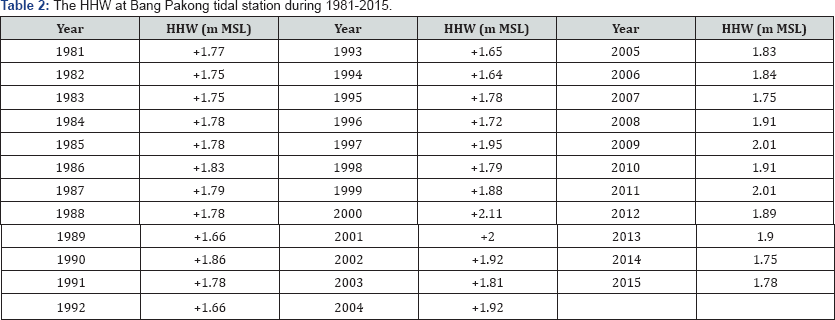
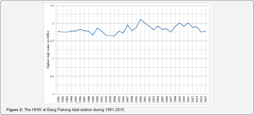
In Samutprakan province, the annual HHW indicated a slightly increasing trend (Table 2 & Figure 2). The annual HHW ranged from +1.64m MSL to +2.11m MSL. After applying the Extreme value analysis, it was found that the value that yielded the highest R2 was 2.0 (Figure 3). The HHW in 100 years at Bang Pakong tidal station was predicted to be 2.14m MSL (Table 3).


Samutsakhon province (ta chen tidal station)
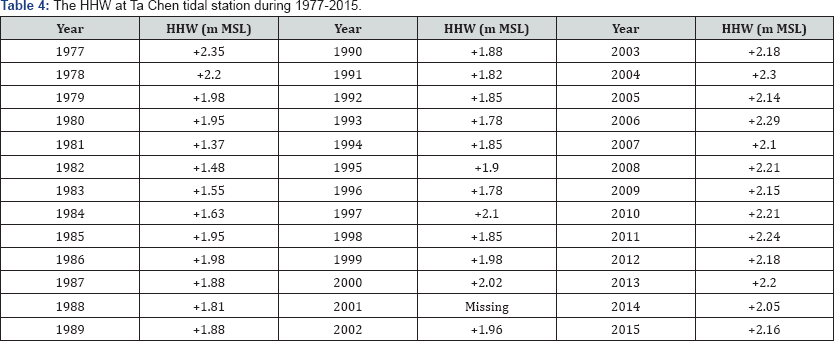
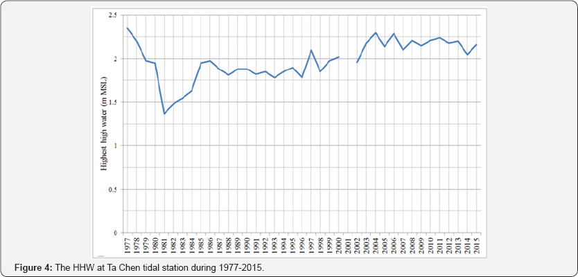
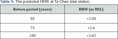
In Samutsakhon province, the annual HHW also presented an increasing trend (Table 4 & Figure 4). The annual HHW ranged from +1.37m MSL to +2.35m MSL. After the Extreme value analysis was undertaken, it was found that the value that yielded the highest R2 was 10.7 (Figure 5). The HHW in 100 years at Ta Chen tidal station was anticipated to be 2.42m MSL (Table 5).
Samutsongkhram province (mae klong tidal station)
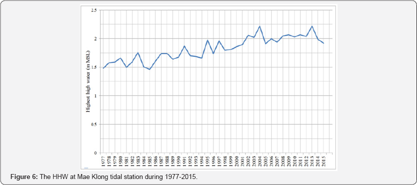
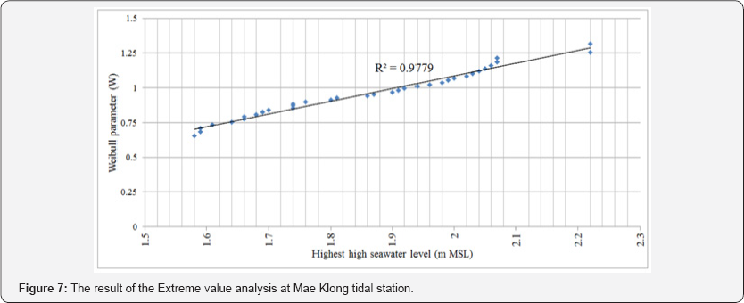
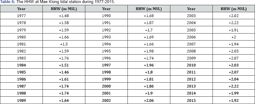
In Samutsongkhram province, the annual HHW also showed an increasing trend (Table 6 & Figure 6). The annual HHW varied from +1.46m MSL to +2.22m MSL. After the Extreme value analysis was completed, it was found that the value that yielded the highest R2 was 5.0 (Figure 7). The HHW in 100 years at Mae Klong tidal station was forecasted to be 2.30m MSL (Table 7).

Discussion and Conclusion
Extreme seawater level is crucial for coastal engineering and management. Many coastal issues occurred along the upper Gulf of Thailand such as coastal inundation and coastal erosion. To address those problems, information on the expected seawater level must be accurately provided. This research gathered past tidal records during 1977 to 2015 from the Marine Department and applied the Extreme value analysis to forecast the 100- year seawater level. The main objective of this research was to quantitatively identify how much the 100-year HHW might be, so that various coastal structures could be suitably designed and coastal management schemes could be effectively implemented.
All tidal stations along the upper Gulf of Thailand suggested an increasing trend of seawater level. The highest seawater level in 100 years at Bang Pakong, Ta Chen, and Mae Klong tidal stations were expected to be +2.14m MSL, +2.42m MSL, and +2.30m MSL respectively. After realizing the possible seawater level in an extreme case, coastal engineers will be able to configure coastal structures such as crest elevation of a breakwater, rock size of a revetment, or deck elevation of a pier. Coastal managers will be able to draw a setback line to manage coastal inundation. These actions cannot be completed unless the HHW in extreme cases are available.
To Know More About Journal of Oceanography Please Click on: https://juniperpublishers.com/ofoaj/index.php
Comments
Post a Comment